


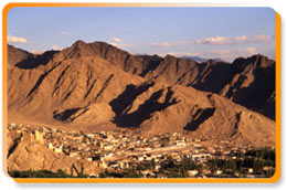
 Ladakh is bounded by two of the world's mightiest
mountain ranges, the Great Himalaya and the Karakoram and lies
transversely to the Ladakh range and the Zanskar range. In geological
terms, it is a young land, formed only a few million years ago by the
buckling and folding of the earth's crust as the Indian sub-continent
pushed with irresistible force against the immovable mass of Asia.
Today, a high-altitude desert, Ladakh was once covered by an extensive
lake system. The remnants of such a lake system still exists in the
southeast plateaus of Rupshu and Chushul where there are drainage basins
such as Tso-moriri, Tsokar, and grandest of all, Pangong-tso. Despite
the rainfall by some stray monsoon clouds that cross over to the area,
the main source of water remains the winter snowfall.
Ladakh is bounded by two of the world's mightiest
mountain ranges, the Great Himalaya and the Karakoram and lies
transversely to the Ladakh range and the Zanskar range. In geological
terms, it is a young land, formed only a few million years ago by the
buckling and folding of the earth's crust as the Indian sub-continent
pushed with irresistible force against the immovable mass of Asia.
Today, a high-altitude desert, Ladakh was once covered by an extensive
lake system. The remnants of such a lake system still exists in the
southeast plateaus of Rupshu and Chushul where there are drainage basins
such as Tso-moriri, Tsokar, and grandest of all, Pangong-tso. Despite
the rainfall by some stray monsoon clouds that cross over to the area,
the main source of water remains the winter snowfall.Drass, Zanskar and the Suru Valley to the north of Himalayas receive heavy snow in winter feeding the glaciers that melt in summers to form the streams used for irrigating the fields. For the rest of the region, the snow on the peaks is virtually the only source of water. Ladakh lies at altitudes ranging from about 9,000 feet at Kargil to 25,170 feet at Saser Kangri in the Karakoram. Its frozen landscape is miraculous while its clear skies with glaring sun are welcome. Shooting stars are visible quite often in the area while silence and tranquility reign the area. There are wizened faces and rosy cheeks, and the dragons and Zen adorn every other human inhabitation, making Ladakh a quite place to visit. Also known as 'The Last Shangrila', 'Moonscape' and 'Little Tibet', the land is full of surprises.
Drass Valley
An enchanting valley formed by the Drass River that has its origin in the Machoi glacier near the famous Zozila Pass. River Shigar flowing in from the north drains a bordering part of the Drass Valley. In summers, due to the melting of snow, the volume of the river rises considerably. It meets the Suru River near Kharul, a short distance away from Kargil. The area is rocky with an occasional green patch formed by willow and groves. The short summer season in the Drass Valley begins in May, when the snows begin to melt. Inhabited by Brokpas who probably migrated to this tract from Gilgit several centuries ago, the chief occupation of the natives is growing mainly barley and other coarse cereals, as there is a lack of irrigation facilities in many parts of Drass. The soil is poor and unproductive and the agricultural production is also poor. As a result, food grains have to be imported from the Kashmir Valley while the scarcity of fuel causes it to be brought in from across the Zozila Pass.
Suru Valley
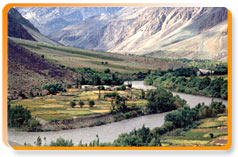 The average height of the Suru valley is 3,000 m. In the winters
starting from mid-November and usually continuing till May, almost all
parts of the valley is covered with a thick layer of snow. Formed by the
catchments of the Suru River, that rises from the Panzella glacier and
joins the Indus River at Nurla and the Dras River at Kharul, the general
topography of the valley is as rugged and mountainous as most of Ladakh.
However, it is relatively more fertile and extends from the Panzella
glacier to south of Kargil town, where the Suru River merges with the
Botkul River rising from the Botkul glacier.
The average height of the Suru valley is 3,000 m. In the winters
starting from mid-November and usually continuing till May, almost all
parts of the valley is covered with a thick layer of snow. Formed by the
catchments of the Suru River, that rises from the Panzella glacier and
joins the Indus River at Nurla and the Dras River at Kharul, the general
topography of the valley is as rugged and mountainous as most of Ladakh.
However, it is relatively more fertile and extends from the Panzella
glacier to south of Kargil town, where the Suru River merges with the
Botkul River rising from the Botkul glacier. Agriculture is the chief occupation of the valley people, which are blessed with a relatively longer summer, which begins in May. The main crops of the region are wheat, barley and millets along with the vegetables such as turnip, radish, peas and black peas. Grapes, apricots and melons are produced in fairly large quantities at Darchik and Garkoon along the lower course of the Indus through Ladakh that find a ready market in Kargil. Liquor is made from grapes.
Nubra Valley
Yellow and pink wild roses cover Nubra during early summers till August when a carpet of wild lavender enwraps it. A relatively warmer valley in Ladakh, it yields better crops and fruits, thus, earning the nickname of the Ldumra or the orchard of Ladakh. Diskit, one of the larger villages in the region, is dotted with apricot plantations and is renowned for housing the 350 year-old Diskit Gompa, which is the oldest and the largest monastery in the Nubra Valley. The road between Diskit and the pretty little Hunder Village winds through a gorgeous stretch of sand dunes. In Hunder, one can see the double-humped camels as one goes to visit the Hunder Gompa having some old frescos and a statue of Buddha. This monastery is also the best place in the village to catch a view of the setting sun.
Salt Lake Valley
One of the widest open areas in Rupshu, it has a length of about 20 km and a maximum width of about 7 km. The average height of the region is 5,000 m and can be approached from Leh across the Tanglang La pass. The main settlement of the valley is Thuggi while the two lakes here are - the fresh water Panluk Lake and the salt-water Tsokar Lake, which is 5 times the area of the former one. Named so because of the deposits of impure salt that occur on the northern shore of the Tsokar Lake, Changpas collect it and use it to barter goods from other parts of Ladakh.
Shyok Valley
The valley of the Shyok River or the river of death, it was called so by the Central Asian traders who ventured on this treacherous route for centuries and perished. Rising from the Khumdang glacier, Nubra and Changchenmo rivers fill the waters of Shylok River. The river freezes in winters forming an easy access between the Khaplu and the Nubra valleys while in summers, as the snow melts in the uplands, the river overflows its banks and create a vast marsh. During this period, the Shyok River has to be crossed on rafts of inflated skin.


